|
Capital: |
Mornington Island 1,007 |
|
Others: |
Jingili people some percentage of ~6,330 Borroloola 773 |
|
Super region: |
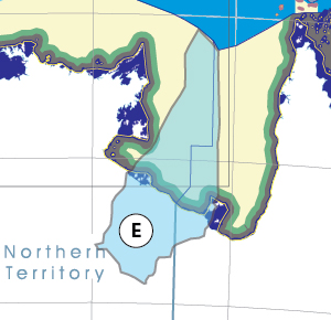
Gulf of Carpentaria B,C,D,E,F,G |
| Hospital: | ???? |
| University: | NO |
| Airport: | http://en.wikipedia.org/wiki/Borroloola_Airport |
|
Basin Authority: |
Robinson McArthur Basin Authority (RMBA)
http://en.wikipedia.org/wiki/Numby_Numby State Pin
|
Thanks for checking this Region out.
This Region is prepared on the a-political concept that if you are interested in 'place' in Australia, the most important aspect that defines 'place', is the 'flow of water'. The Senate is interested in 'place'.
This Region defines its boundaries at the top of the ridge, where water flows one way rather than the other. This leads to a very interesting 'place'.
We are seeking a debate with people who live in this proposed new Region. We know we've got the Region pretty well correct; after all, it's just geography. But if you live in this Region you can tell us a lot of interesting things.
- Do these boundaries define a place that is unique; different to every other Region in Australia? We think that that is probably quite likely.
- Is it a great place, worthy of recognition?
- Upon formation, what should be the name of this Region? Who would be the Lord Mayor? Who would be the two Senators who represent this Region? Who would be the additional Senator that represents the interests of Aboriginal & Torres Strait Islander peoples in this region? What benefit would flow from a concept of a the super-Region for the whole of the Gulf of Carpentaria?
- Would life be enhanced if it was on a fast Ring-Rail that links the Capital City to every other Capital City in Australia?
- Many other interesting things!
We think that this is a great new concept of regional statehood based on real concepts that define life in this particular Region. What do you think?
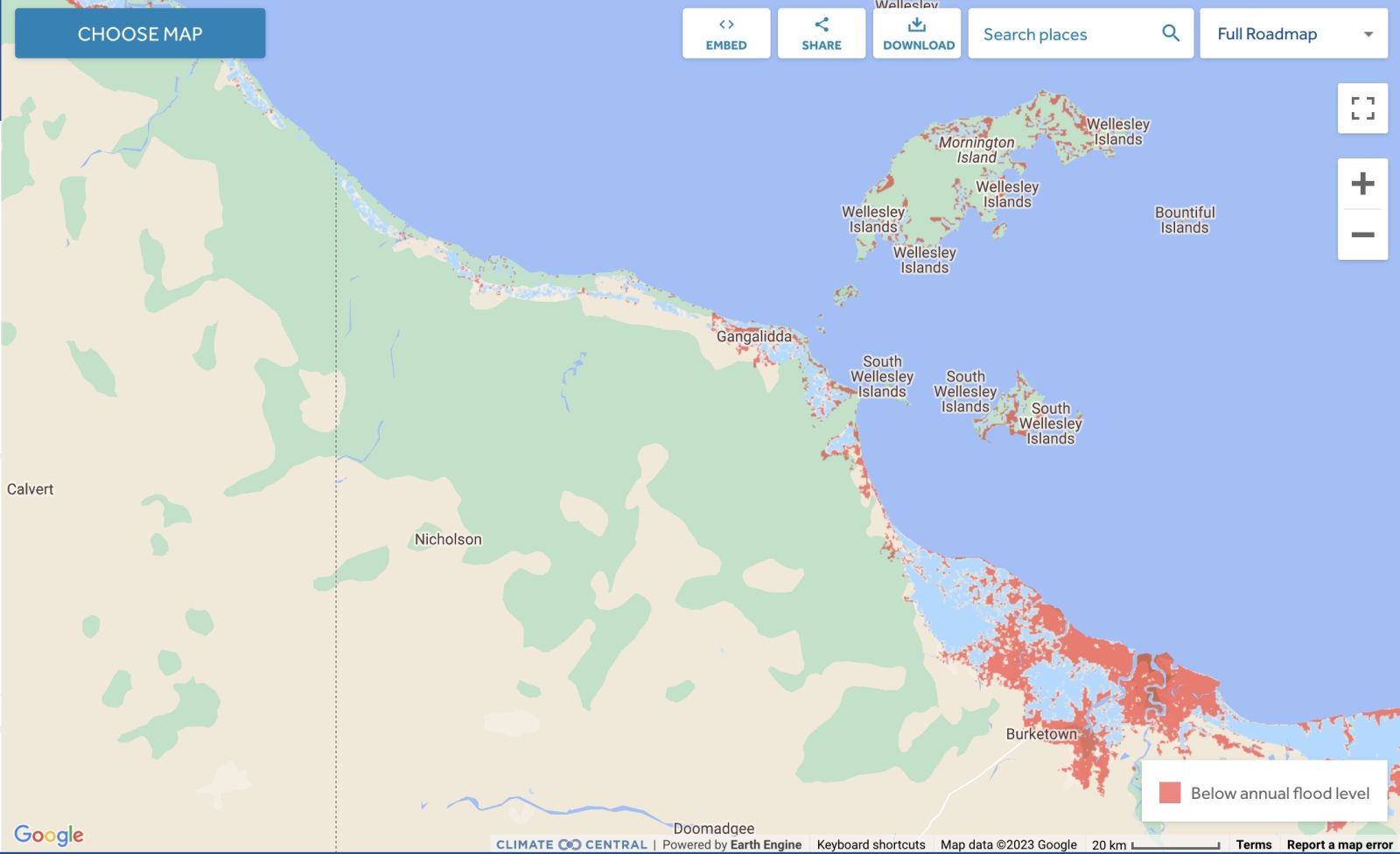
Land projected to be below annual flood level in 2050
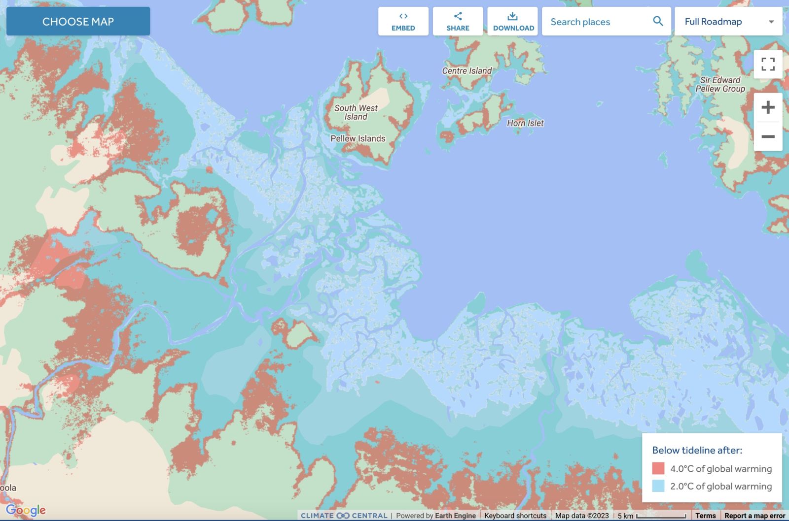
Comparison: long-term sea level outcomes
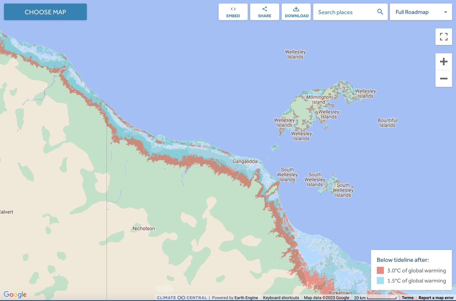
Comparison: long-term sea level outcomes
|
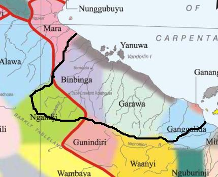
Aboriginal Australia:
|
|
|
|
|
NOTE1: Likely indicators only; for original Aboriginal Australia Map © 1991 & restrictions on its copy & use, see Aboriginal Australia Map NOTE2: The red line is part of the original Aboriginal Australia Map © 1991. The black line is added by Bloggerme for discussion only. It shows the likely State boundary based on the flow of water only. As "the ridge" (See FOWTOR) naturally impacts on the development of the language, social or nation groups of the Indigenous people of Australia, the proposed border is often identical to the group boundary shown on the Aboriginal Australia Map. This is as was expected. Variations are social/historical & result in a particular language, social or nation group being represented in two adjoining States. |
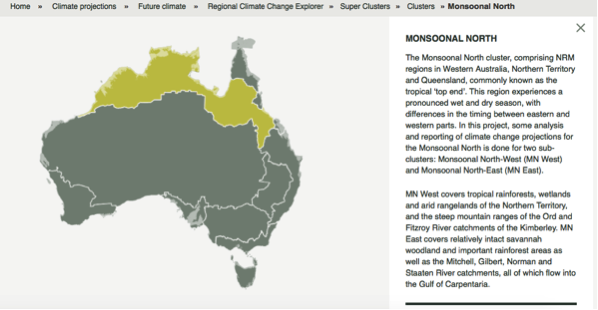 |
Other regional projections - CSIRO part of Monsoon North regionThe CSIRO has regions for projecting the impact of Climate Change. See https://www.climatechangeinaustralia.gov.au/en/climate-projections/futur... This state, Borroloola State (E), is one of the clear projections in a CSIRO cluster called "Monsoon North region". CSIRO's Monsoon North region coincides exactly with BloggerMe's K,J,H,G,F,E,D,C,AF. |
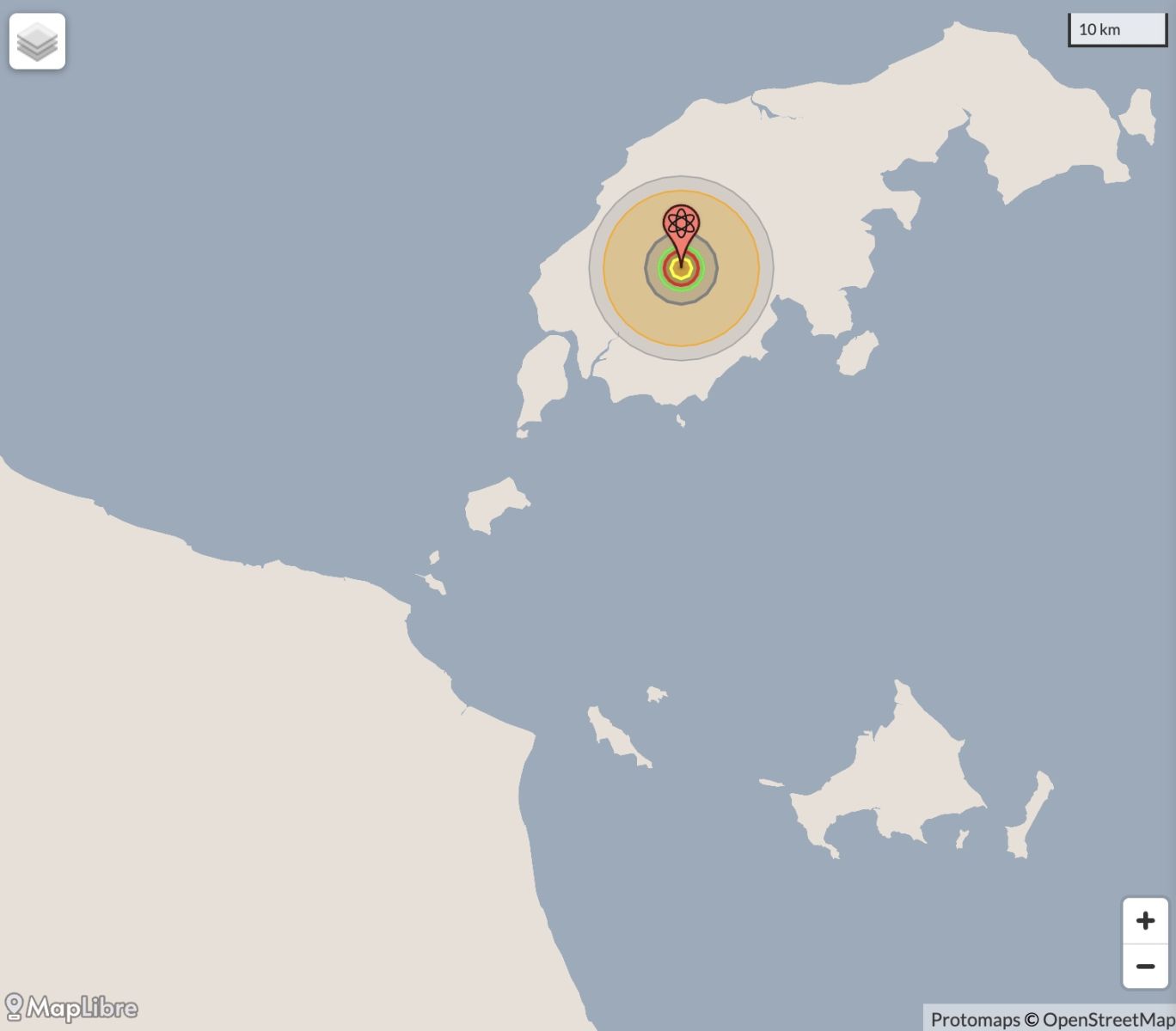
Nuclear weapons
Centre ground zero CGZ - Mornington Island - 475 kilotons (431 kilotonnes)
https://nuclearsecrecy.com/nukemap/
Click here to:
Comments
Steve Irons
Tue, 06/10/2020 - 7:25pm
Permalink
Beauty
Traditional dancers from Mornington Island
https://www.pinterest.com/pin/418553359094252875/
Sunrise over their dam on Mornington Island
https://www.pinterest.com/pin/418553359094252969/
Sunset over Mornington Island
https://www.pinterest.com/pin/418553359094253099/
Sunset over Mornington Island
https://www.pinterest.com/pin/418553359094253271/
McArthur River mine
https://www.pinterest.com/pin/418553359095191068/
Lawn Hill Gorge, Boodjamulla National Park
https://www.pinterest.com/pin/418553359095872334/
Steve Irons
Sat, 15/03/2014 - 5:06pm
Permalink
Ex-tropical cyclone Gillian
http://www.bom.gov.au/products/IDD65012.shtml
Steve Irons
Thu, 13/03/2014 - 12:09am
Permalink
Ex-tropical cyclone Gillian
http://www.bom.gov.au/products/IDQP0012.shtml
Steve Irons
Wed, 05/02/2014 - 12:00am
Permalink
Tropical Cyclone Fletcher
http://www.bom.gov.au/australia/meteye/
Steve Irons
Tue, 04/02/2014 - 11:47pm
Permalink
Tropical Cyclone Fletcher
http://www.bom.gov.au/products/IDQ65002.shtml
Twitter
Sat, 02/03/2013 - 7:14pm
Permalink
driest wet season on record
Top End Tweets @TopEndTweets
Top End sweats on rain as Wet goes walkabout: The weather bureau says this wet season in the Northern ... http://j.mp/146Dkx8
Twitter
Mon, 26/11/2012 - 7:00am
Permalink
Heartbreak highway
Top End Tweets @TopEndTweets
Heartbreak highway: A WOMAN is recovering after spending more than a week hovering in critical condition... http://j.mp/TaGuLh
Twitter
Fri, 16/11/2012 - 9:23pm
Permalink
RDA Blogs - Mornington Island
Top End Tweets @TopEndTweets
http://indigenous.gov.au : Mornington Island is committed to promoting respect http://j.mp/WcbY9K
Twitter
Fri, 09/11/2012 - 9:05pm
Permalink
Cape Londonderry to Cape York
CSIRO @CSIROnews
Prawns this Xmas? Our research collaboration - the Northern Prawn Fishery - is now certified as sustainable! http://ow.ly/f97gV
Add new comment