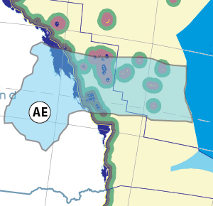
Thanks for checking this Region out.
This Region is prepared on the a-political concept that if you are interested in 'place' in Australia, the most important aspect that defines 'place', is the 'flow of water'. The Senate is interested in 'place'.
This Region defines its boundaries at the top of the ridge, where water flows one way rather than the other. This leads to a very interesting 'place'.
We are seeking a debate with people who live in this proposed new Region. We know we've got the Region pretty well correct; after all, it's just geography. But if you live in this Region you can tell us a lot of interesting things.
- Do these boundaries define a place that is unique; different to every other Region in Australia? We think that that is probably quite likely.
- Is it a great place, worthy of recognition?
- Upon formation, what should be the name of this Region? Who would be the Lord Mayor? Who would be the two Senators who represent this Region? Who would be the additional Senator that represents the interests of Aboriginal & Torres Strait Islander peoples in this region?
- Would life be enhanced if it was on a fast Ring-Rail that links the Capital City to every other Capital City in Australia?
- Many other interesting things!
We think that this is a great new concept of regional statehood based on real concepts that define life in this particular Region. What do you think?
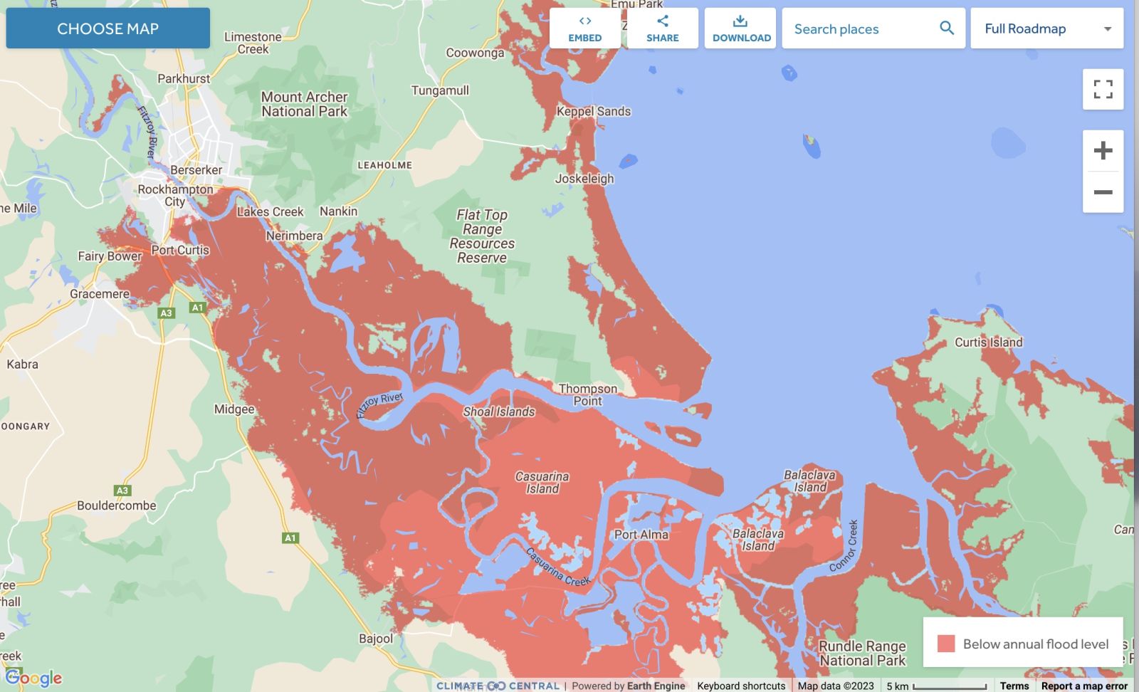
Land projected to be below annual flood level in 2050
Comparison: long-term sea level outcomes
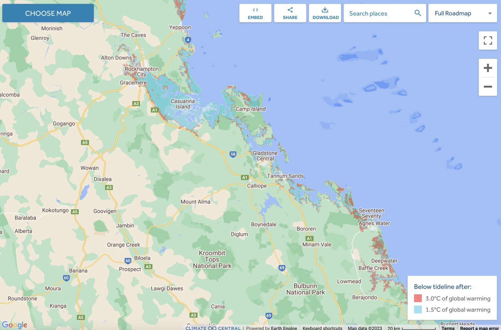
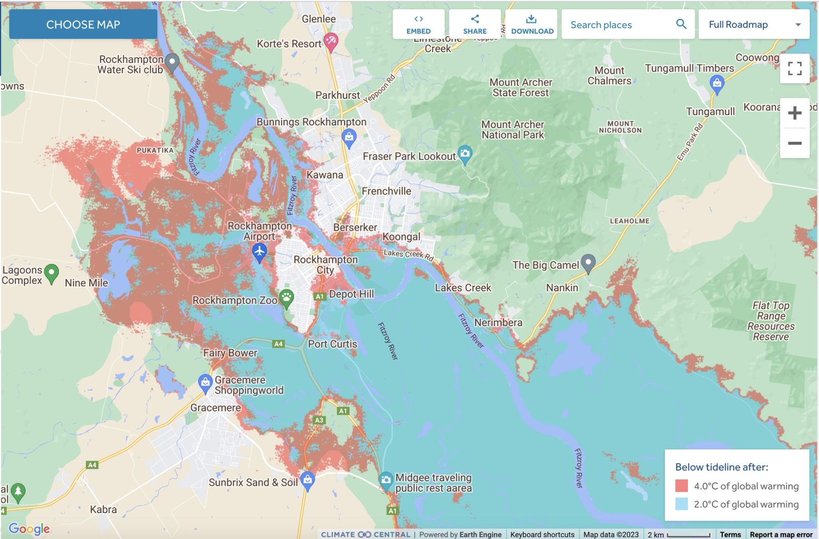
Comparison: long-term sea level outcomes
|
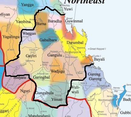
Aboriginal Australia:
|
|
|
NOTE1: Likely indicators only; for original Aboriginal Australia Map © 1991 & restrictions on its copy & use, see Aboriginal Australia Map NOTE2: The red line is part of the original Aboriginal Australia Map © 1991. The black line is added by Bloggerme for discussion only. It shows the likely State boundary based on the flow of water only. As "the ridge" (See FOWTOR) naturally impacts on the development of the language, social or nation groups of the Indigenous people of Australia, the proposed border is often identical to the group boundary shown on the Aboriginal Australia Map. This is as was expected. Variations are social/historical & result in a particular language, social or nation group being represented in two adjoining States. |
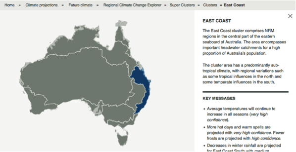 |
Other regional projections - CSIRO part of East Coast regionThe CSIRO has regions for projecting the impact of Climate Change. See https://www.climatechangeinaustralia.gov.au/en/climate-projections/futur... This state, Capricorn State (AE), is one of the clear projections in a CSIRO cluster called "East Coast region". CSIRO's East Coast region coincides exactly with BloggerMe's Y,Z,AA,AB,AC,AE. |
Nuclear weapons
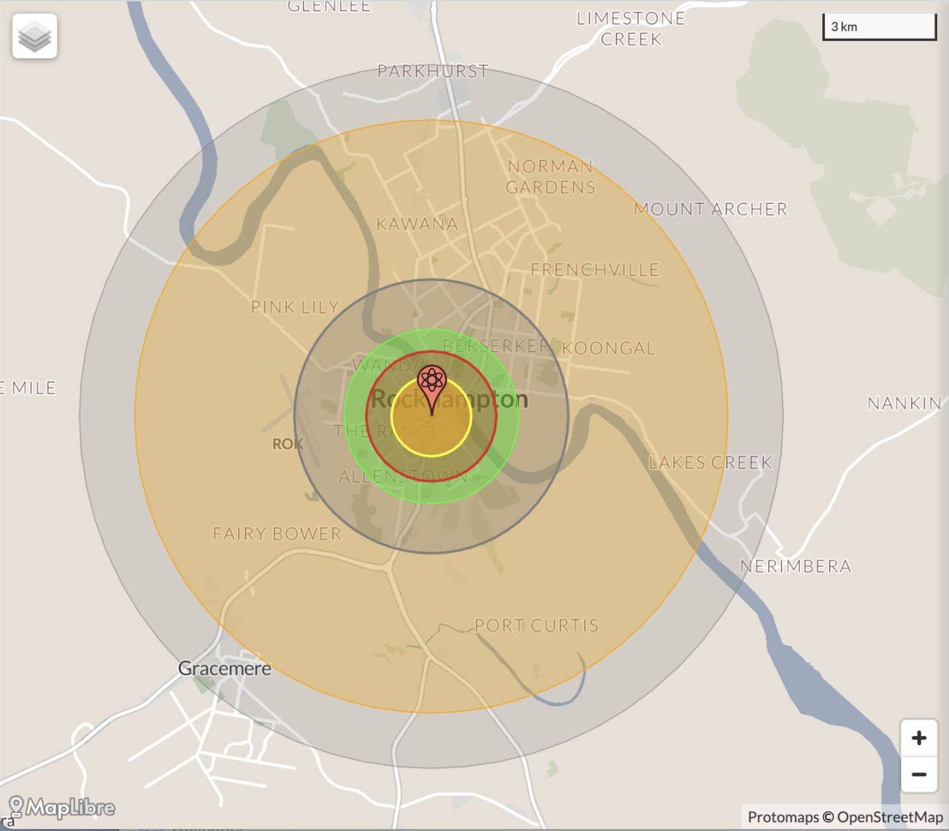
Centre ground zero CGZ - Rockhampton - 475 kilotons (431 kilotonnes)
https://nuclearsecrecy.com/nukemap/
NB: population 10km around Rockhampton CBD LEGEND
https://australia.places-in-the-world.com/11523835-places-within-10km-ar...
Population taken out by nuclear weapon = 69,331
Click here to:

Comments
Steve Irons
Tue, 06/10/2020 - 6:44pm
Permalink
Beauty
Hamilton Island
https://www.pinterest.com/pin/418553359093933365/
Whitsundays
https://www.pinterest.com/pin/418553359093933365/
Whitehaven Beach
https://www.pinterest.com/pin/418553359093989975/
TCMarcia, Floodwater Bruce Highway
https://www.pinterest.com/pin/418553359094708931/
TCMarcia "grazes" Yeppoon
https://www.pinterest.com/pin/418553359094708998/
Hamilton Island
https://www.pinterest.com/pin/418553359094782037/
Carnarvon Gorge National Park
https://www.pinterest.com/pin/418553359095905797/
Hamilton Island
https://www.pinterest.com/pin/418553359096122430/
Steve Irons
Fri, 20/02/2015 - 5:38pm
Permalink
TCMarcia hit Rockhampton 4 now at 3 Gladstone
TCMarcia came in Cat 5, hit Rockhampton Cat 4 now moving SW of Gladstone, towards Biloela. Cat 3, winds up to 165kmh - @BoM_Qld
Steve Irons
Fri, 20/02/2015 - 3:44am
Permalink
Change of direction - now coming in at Yepoon
Coming in over Townshend Island & heading for Yepoon. https://www.pinterest.com/pin/418553359094700855/
Steve Irons
Thu, 19/02/2015 - 8:54pm
Permalink
TC Marcia to enter at Mackay
TC Marcia enters at Mackay
Twitter @EarthUncutTV 13 mins13 minutes ago
Extremely serious situation for Australia as #CycloneMarcia bombs out before landfall, projected cat 5 by BoM
Steve Irons
Thu, 19/02/2015 - 8:22pm
Permalink
Tropical cyclone Marcia - to hit Land between Mackay & Gladstone
http://www.abc.net.au/news/2015-02-19/live-blog-tropical-cyclone-marcia-...
"What you need to know about Tropical Cyclone Marcia.
"This afternoon Tropical Cyclone Marcia was upgraded to a category four system.
"It is expected to make landfall between Mackay and Gladstone, lashing the areas with destructive gusts of up to 270 kilometres per hour (kph) at about 3:00am Friday.
Higher than normal tides, dangerous surf conditions and rainfall totals exceeding 500mm over a 24-hour period in some areas are forecast, bringing a risk of tidal and flash flooding.
"In a press conference this morning, Queensland Premier Annastacia Palaszczuk told residents to 'get ready now'.
"Flights in-and-out of the region have been cancelled.
"For help during a flood or storm call the SES on 132 500; for life-threatening emergencies call 000.
"ABC Local Radio will have continuous coverage through the night and into the morning as the cyclone makes landfall."
READ more: http://www.abc.net.au/news/2015-02-19/live-blog-tropical-cyclone-marcia-...
Watch it develop https://www.pinterest.com/pin/418553359094694090/
Some comments on Twitter @MichelleSuiter The latest satellite image of Aus, currently being attacked from 2 sides by Mother Nature, although looks like 3
Twitter
Thu, 10/01/2013 - 3:23am
Permalink
Whitsundays
ABC Far North QLD @ABCFarNorth
Port owner rejects dredging will harm Barrier Reef http://bit.ly/ZyYM0r
Twitter
Tue, 01/01/2013 - 7:26pm
Permalink
CSG - Factbox map of Australia
Mike Millard @RobinHood1776
Factbox: CSG in Australia http://www.sbs.com.au/news/article/1626037 …
Twitter
Tue, 01/01/2013 - 7:24pm
Permalink
CSG on marine life & reef
Mike Millard @RobinHood1776
Coal Seam Gas Threatens Coastline Water Contamination http://www.sbs.com.au/news/article/1723186/CSG-water-may-pose-risk-to-coast-expertsvia …@sbsnews
Twitter
Tue, 18/12/2012 - 10:54am
Permalink
Diuron
Meredith Stanton @CloudsCreek
Ban Lethal Herbicide Near Great Barrier Reef http://www.thepetitionsite.com/411/584/102/ban-lethal-herbicide-near-great-barrier-reef/#bbtw=450903454 …
Twitter
Thu, 06/12/2012 - 5:20am
Permalink
Coordinates missing island
Ben Cubby @bencubby
This is why I was asking about co-ordinates. Great story by @NickySMH http://bit.ly/11uPGAH
Twitter
Thu, 06/12/2012 - 2:15am
Permalink
Great Barrier Reef
FarmOnline @FarmOnline
Bid to save green tape: A GROUP of Australia's most respected scientists is urging the federal government to aba... http://bit.ly/11Jd7Wb
Twitter
Fri, 23/11/2012 - 11:05pm
Permalink
Island disappears
vexnews @vexnews
Where did it go? Scientists 'undiscover' Pacific island http://bit.ly/Y4GxPi
Twitter
Fri, 09/11/2012 - 1:13pm
Permalink
Coral is under threat
ABC Far North QLD @ABCFarNorth
Saudi, Australian experts unite to save coral http://bit.ly/TwdOLA
Twitter
Wed, 07/11/2012 - 12:58pm
Permalink
War on graffiti
Keep Aust Beautiful @KABNAHQ
Mackay Regional Council declares war on graffiti | Rockhampton Morning Bulletin http://www.themorningbulletin.com.au/news/mackay-regional-council-declares-war-graffiti/1609447/ …
Twitter
Thu, 25/10/2012 - 1:21am
Permalink
Stolen wages meeting in Mackay
Luke Pearson @LukeLPearson
BAM!! 'Qld elders want Campbell Newman to stop wearing the Aboriginal and Torres Strait Islander flags on his lapel' http://www.sbs.com.au/podcasts/Podcasts/radionews/episode/238751/Queensland-elders-flag-stolen-wages-fight …
Steve Irons
Sun, 14/10/2012 - 3:17am
Permalink
Rough draft - Great Barrier Reef
http://bloggerme.com.au/super-state-1-great-barrier-reef
Add new comment